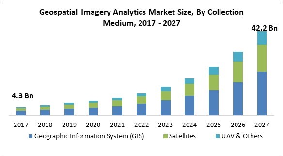
The Global Geospatial Imagery Analytics Market size is expected to reach $42.2 billion by 2027, rising at a market growth of 29.5% CAGR during the forecast period.
Geospatial data is information on things, events, or other features that have a physical location on or near the ground surface. Location information (generally coordinates on the earth) and associated information (the qualities of the item, event, or phenomenon in question) are frequently combined with temporal information in geospatial data. In the coming years, the location supplied may be stationary (for example, the position of a piece of equipment, an earthquake incident, or children living in poverty) or variable (for example, the location of a piece of machinery, an earthquake event, or children living in poverty).
Large sets of geographical data obtained from a variety of sources in various forms, like census data, weather data, satellite imagery, mobile phone data, social media data, and drawn pictures are all examples of geospatial data. When geospatial data can be found, shared, analysed, and combined with standard business data, it is most helpful.
Geospatial analytics is utilized to add time and location to standard data sets and to create data visualisations. Maps, graphs, statistics, and cartograms are examples of visualisations that depict historical and contemporary shifts. This added information helps to paint a fuller picture of what happened. Easy-to-recognize visual patterns and pictures show insights that can be ignored in a large spreadsheet.
The massive amounts of data created by GPS devices throughout the world are a remarkable development that is driving demand for geospatial imaging analytics solutions. Furthermore, the widespread use of connected mobile devices, notably smartphones, in many economies throughout the world is propelling market expansion. The government sector's high need for GIS for law and security is propelling the industry forward. The fast advancements in GIS technology and methods for retrieving geographic information would assist the total industry significantly.

COVID-19's spread has wreaked havoc on the world's companies, economies, and people's lifestyles, as well as the ways taken by corporations to manage their operations. The COVID-19 epidemic has affected every aspect of the technology industry. In the IT industry, the hardware business is expected to have the greatest influence. The expansion of IT infrastructure has slowed due to a decrease in hardware supply and reduced manufacturing capacity. For a short period of time, the software and service industries are also projected to slow down.
However, in the second half of the year, usage of collaborative apps, location-based apps, big data, security solutions, and AI is expected to rise. Despite the fact that the pandemic has had an impact on the geospatial imaging analytics industry, businesses continue to use geospatial imagery analytics solutions and personnel tracking and management, virus tracking, smart quarantining and hardware for facility management.
Spatial information and location with interconnected systems systems - Big Data, Augmented Reality, Machine Learning, Artificial Intelligence, IoT, and 3D systems - are going to transform the core of traditional company practises, providing competitive advantages through data visualisation, analytics, and digital perspectives - an ever-increasing necessity real-time information - in this data-driven manufacturing era. The spatial context remains an essential element and a core instrument for workflow management, smart applications, and a major platform for automated processes in manufacturing, architecture, telecommunications, intelligent transportation, technology, and many other sectors, in addition to archetypal businesses like governance, urban planning, defense, and internal security.
Location-based services (LBS) are understood as a software service that uses Internet-capable computers to provide real-time information on the current location of a place or person. LBS uses satellite images to enable users to access the service in a variety of apps, including retail, urgent care, weather, browsing, traffic, and other services. Satellite imaging technology delivers high-resolution images that may be utilized to create up-to-date, highly specific maps for LBS and real-time applications. In addition, LBS is becoming increasingly significant in a variety of economic areas, including public, defense, and intelligence, communications, transportation, production, power, energy retail, and natural resource governance, supporting market growth.
Due to the growing rate of urbanization throughout the world, Geospatial Deployment in the urban development business may yet encounter certain challenges. With the increasing rate of migration from rural to urban areas and urban demographic growth, geospatial applications are challenging to apply unless assessments and population-to-land tests are conducted on a regular basis and perhaps real-time data is provided. According to the United Nations, the globe will have around 500 million cities by 2030. The growing number of these cities is an indicator of extremely fast urbanization.
They can cause problems for government and planning agencies. As such big projects would require huge financial investments, government, public, and developer teams operating in isolation will then need to communicate information with the primary data centers.

Based on Type, the market is segmented into Image-based Analytics and Video Analytics. Due to the increased usage of drones and security cameras by businesses to analyses and exploit video footage to support their everyday operations, video-based analytics is predicted to rise rapidly throughout the forecast period. Video recording and analysis devices are also available from the firms, which are perfect for recording videos for mobile mapping studies, real-time reporting, as well as post-mission mapping.
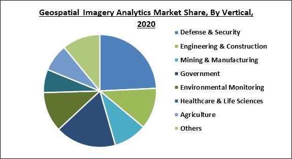
Based on Vertical, the market is segmented into Defense & Security, Engineering & Construction, Mining & Manufacturing, Government, Environmental Monitoring, Healthcare & Life Sciences, and Agriculture. In the agriculture industry, geospatial imaging analytics is assisting in ensuring crop safety and sensible use of natural resources. Using remote sensing tools, the government is launching new projects to enhance farming operations.
Based on Collection Medium, the market is segmented into Geographic Information System (GIS) and Satellites. Due to a growth in the use of GIS in remote sensing applications, the GIS collection medium represented the largest share of the geospatial imagery analytics market. Businesses are shifting to the GIS data collecting approach as demand for location-based analytics services rises, allowing them to better their overall efficiency and decision-making.
Based on Deployment Type, the market is segmented into On-premise and Cloud. Due to the enterprise-level implementation of geospatial imagery analytics solutions on their servers to store their material locally, the on-premise deployment strategy had a significant share in 2020. This deployment enables businesses to get complete control over their current geospatial datasets and conduct data analysis to uncover new patterns, trends, and anomalies.
Based on Organization Size, the market is segmented into Large Enterprises and Small & Medium Enterprises. The SMEs sector of the Geospatial imagery analytics market is expected to develop at a higher rate during the projected period, as cloud-based solutions and services assist them improve company performance and efficiency.
Based on Application, the market is segmented into Disaster Management, Construction & Development, Conservation & Research, Exhibition & Live Entertainment and Surveillance & Monitoring. During the projection period, the increasing usage of remote sensing services will increase surveillance and monitoring adoption.
| Report Attribute | Details |
|---|---|
| Market size value in 2020 | USD 7.4 Billion |
| Market size forecast in 2027 | USD 42.2 Billion |
| Base Year | 2020 |
| Historical Period | 2017 to 2019 |
| Forecast Period | 2021 to 2027 |
| Revenue Growth Rate | CAGR of 29.5% from 2021 to 2027 |
| Number of Pages | 396 |
| Number of Tables | 672 |
| Report coverage | Market Trends, Revenue Estimation and Forecast, Segmentation Analysis, Regional and Country Breakdown, Competitive Landscape, Companies Strategic Developments, Company Profiling |
| Segments covered | Type, Collection Medium, Deployment Type, Organization Size, Application, Vertical, Region |
| Country scope | US, Canada, Mexico, Germany, UK, France, Russia, Spain, Italy, China, Japan, India, South Korea, Singapore, Malaysia, Brazil, Argentina, UAE, Saudi Arabia, South Africa, Nigeria |
| Growth Drivers |
|
| Restraints |
|
Based on Regions, the market is segmented into North America, Europe, Asia Pacific, and Latin America, Middle East & Africa. During the projection period, Asia Pacific will see a significant increase in the usage of geospatial imagery analytics products and services. The geospatial imagery analytics market in APAC is being driven by increased data quantities, developments in AI and big data technologies, rising concerns about data quality, and rising need for meaningful insights. China and Japan are working on improving data management in order to allow data-driven business choices and streamline corporate operations.
Free Valuable Insights: Global Geospatial Imagery Analytics Market size to reach USD 42.2 Billion by 2027

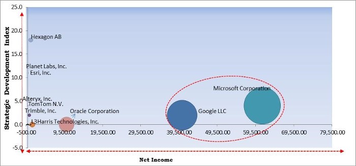
The major strategies followed by the market participants are Partnerships. Based on the Analysis presented in the Cardinal matrix; Google, LLC and Microsoft Corporation are the forerunners in the Geospatial Imagery Analytics Market. Companies such as Oracle Corporation, TomTom N.V., and Hexagon AB are some of the key innovators in the Market.
The market research report covers the analysis of key stake holders of the market. Key companies profiled in the report include Trimble, Inc., Microsoft Corporation, Google LLC, TomTom N.V., Hexagon AB, L3Harris Technologies, Inc., Planet Labs, Inc., Oracle Corporation, Alteryx, Inc.
By Type
By Vertical
By Collection Medium
By Deployment
By Organization Size
By Application
By Geography
The global geospatial imagery analytics market size is expected to reach $42.2 billion by 2027.
Geospatial In The Digital Environments are driving the market in coming years, however, Urbanization and population growth are both on the rise limited the growth of the market.
Trimble, Inc., Microsoft Corporation, Google LLC, TomTom N.V., Hexagon AB, L3Harris Technologies, Inc., Planet Labs, Inc., Oracle Corporation, Alteryx, Inc.
The Cloud market has high growth rate of 31.4% during (2021 - 2027).
The North America region shows high market share in the Global Geospatial Imagery Analytics Market by Region 2020, and would continue to be a dominant market till 2027.
Our team of dedicated experts can provide you with attractive expansion opportunities for your business.
